
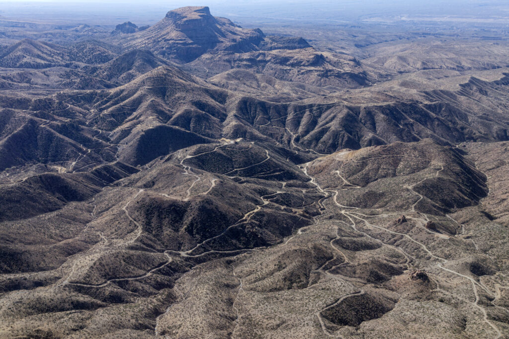
Aerial view of the Copper Creek exploration area by Faraday/Redhawk reveals
a series of drill pads and widened roads impacting this vital water source and
wildlife connectivity corridor. Photo by Elias Butler
Our neighbors in Mexico living along the southernmost stretch of the San Pedro River are facing nightmarish challenges. Ranchers’ and residents’ wells have run dry. Aquifers are tapped out. The subflow beneath their stretch of the river has dried up.
Are we next?
There are a number of issues at play in Mexico: a copper mine (Grupo Mexico) pilfering precious water resources from the river, a 25-year megadrought, and rising temperatures that suck up standing water. In other words: the same issues our communities face – or soon may face – if Canadian Faraday Copper sells its ‘exploration package’ to the next big foreign mining interest that comes to town.
Since the 1990s, Chris Eastoe, San Pedro Valley resident and former staff scientist at the University of Arizona’s Department of Geosciences, has been studying the health of the San Pedro in Cascabel, as well as the flow of springs in the Galiuro Mountains near Copper Creek. He shared his findings at the Feb. 11 public meeting hosted by the Lower San Pedro Watershed Alliance (LSPWA).
What he’s documented is alarming. Wells and perennial reaches along the river – at Three Links Farm, near Gamez Road, and Hot Springs Canyon, with similar geology to the Mammoth area – have shown declining water availability since 1993. One well has even collapsed. Several of the once-active springs in the Galiuros have completely dried up.
“Research by the U.S. Geological Survey (USGS) has shown that water recharge is not sufficient to maintain water levels,” said Eastoe. Overpumping along the river, decades of progressive drying, and megadrought are to blame. He shared maps of the river which illustrate, visually, over a period of 10 years, the number of areas that transitioned from standing water to no flow, a scientific process called wet-dry mapping (see figure A).
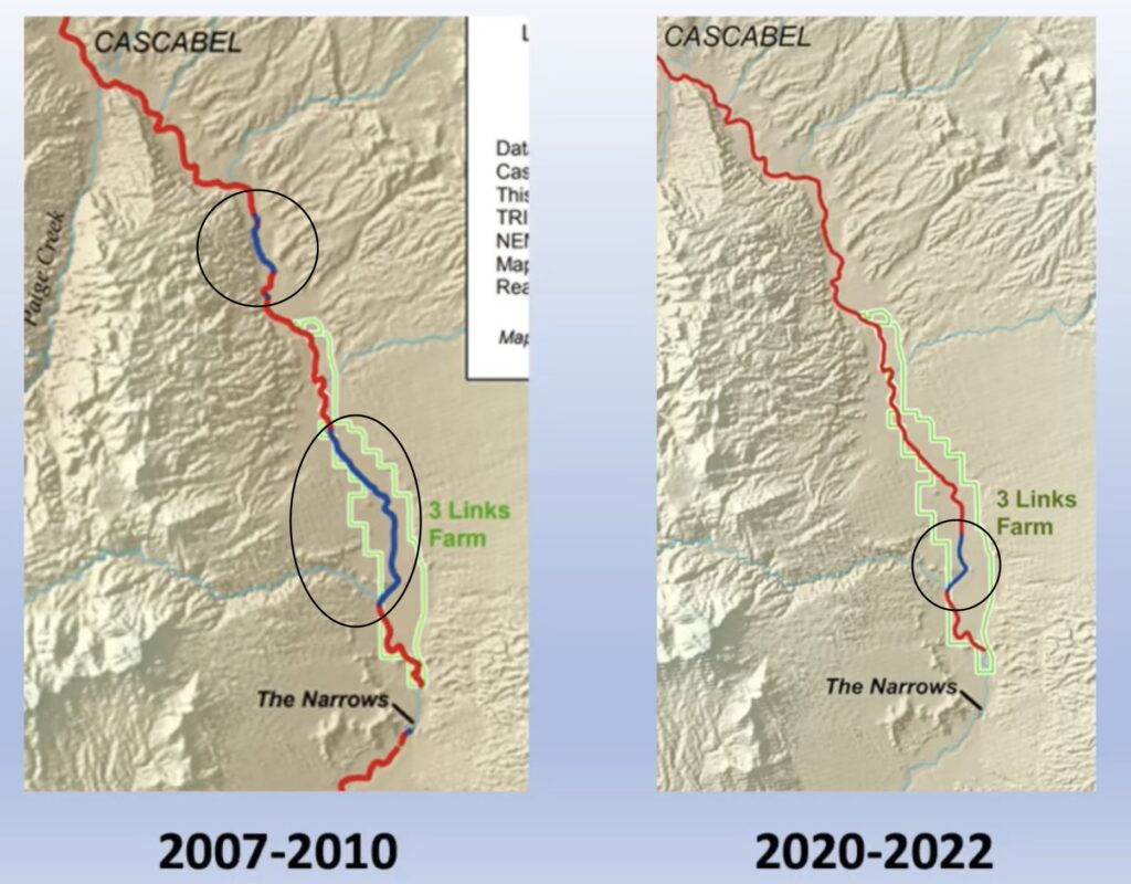
Figure A: Studies conducted by The Nature Conservancy. Red = Dry, Blue = Wet. The circled areas indicate the only surface water still present along the river.
Add more mining to the mix, and local communities – residents and ranchers alike – are likely to see hard times like our neighbors to the south. When it will happen isn’t determined, said Eastoe.
But, knowing the geology of the mountains and the river, he warned, “If you are pulling water out of drainages that come laterally from the Galiuros – like Copper Creek – you are robbing the aquifer in the middle of the San Pedro River basin.” The Bureau of Land Management (BLM), in its recent Environmental Assessment for Redhawk (parent company Faraday Copper), indicated that 35 gallons of water per minute, per drill rig, is flowing through the mining company’s hoses from private wells as they perform exploratory mining in the Galiuros.
At the Feb. 11 LSPWA meeting, Eastoe suggested that water for future, full-scale mining will likely be drawn from aquifers close to the San Pedro. “This is your part of the territory, near Aravaipa Wash,” Eastoe pointed to a graphic (Figure B). “This is the area where the groundwater is abundant and where a mining company that needs a large water supply will be drilling wells to get the water.”
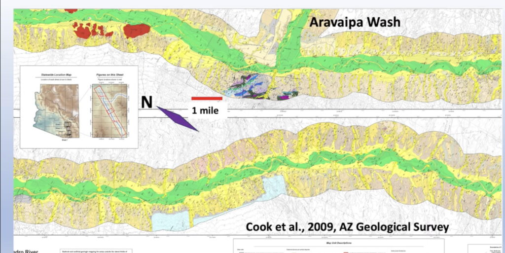
Figure B: AZ Geological Study by Cook, et. al. Green areas showcase the healthiest water flows in the Lower San Pedro.
Redhawk hasn’t disclosed where they’ll source the water for their senior buyer’s proposed full-scale operations. They’ve been asked at public meetings over the course of two years and have said, “We don’t know,” because, by law, they don’t have to present hydrological details during exploration, or even know which aquifers they might tap. Under 1872 Mining Law, they can use unlimited water during exploratory drilling with very little required monitoring. They also don’t pay for it.
It wouldn’t be the first time mining companies have accessed the San Pedro aquifer for water. A site visit by the Environmental Protection Agency to then-Magma Copper in 1992, documented “a cone of depression in the area’s water table … that encompassed an area eight miles in diameter” and that “impacted water levels in all directions, except to the south and southwest where recharge occurs from the Santa Catalina Mountain Block.” Add to that 44-year period of water withdrawal the history of Tiger and Mammoth Mines, and it becomes clear that the San Pedro River Valley has seen extraordinary underground-water extraction from the mining industry, which, with current climatic and drought conditions, presents additional concerns.
Consider, also, that the Bureau of Land Management recently approved Notice-Level drilling in the Tucson Wash by Australian junior mining company, Metallica/Golden Mile Resources Limited. The question becomes: How much withdrawal can the local area’s underground reserves sustain? They are not unlimited, as learned by our Mexican neighbors.
Eastoe says it depends on whether the water is being drawn from an already-impacted area or one with multiple, simultaneous withdrawals, and on the amount of recharge in a particular area. The problem, again, is that exploratory mining doesn’t require extensive hydrologic study, and the community will be hard pressed to find those answers. During a March 6 public meeting, BLM hydrologist Matt Stewart said, of the Galiuros, “The hydrology of the area is not well characterized.”
One thing is clear to Eastoe. “The more draws you have in an aquifer, the faster that level will go down if it’s not being replenished fast enough to counteract the withdrawal.” USGS studies, available on the Lower San Pedro Watershed Alliance website, show that recharge is not keeping up – even without full-scale mining and with some retired agricultural uses. “Eventually people’s wells will go dry. It might not be immediately; it might take decades.”
Under current law, there is no blanket legal requirement for mining companies to pay for deeper community wells if they cause existing wells to go dry, a distressing fact given that 40 percent of Arizona’s water supply comes from underground sources. In the Lower San Pedro River valley, communities rely on it 100 percent.
In the end, said Eastoe,“Our communities need to weigh the benefits of whatever jobs they think will become available, against the changes to their environment.”
The public has until April 14 to comment on BLM’s Environmental Assessment of Faraday/Redhawk’s exploratory drilling proposal. A community workshop will be held April 1, 6-7:30 p.m. at the Wilson Barn in Oracle (2246 W Linda Vista Road, Oracle AZ 85623) – and also via Zoom – to learn more about writing effective EA responses. For more information: https://www.lowersanpedro.com/what-we-do/ea-comments-workshop
Melissa Crytzer Fry is a science journalist, Mammoth resident and board officer with the Lower San Pedro Watershed Alliance.