

The Legends of Superior Trails: Pinal to the Arizona Trail.
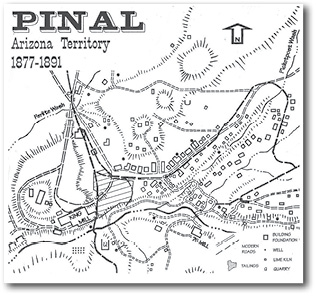
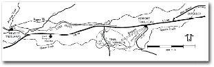
A map of Pinal City, one of the destinations of the Legends of Superior Trail.
By Mila Besich Lira
Pinal Nugget
The Legends of Superior Trails is a new outdoor hiking, biking and equestrian trail that provides both safe access to the Arizona National Scenic Trail, but also is designed to preserve and promote the many legends around Superior.
Over the past five years a partnership of businesses and government agencies have worked together to map, construct, and market the trail. Hundreds of volunteer hours were given to clean up and build the trail. The partnership consists of representatives from the Tonto National Forest, Town of Superior, Arizona Trail Association, Arizona Game and Fish as well as Resolution Copper Company. The Superior Chamber of Commerce and the Copper Corridor Economic Development Coalition have also contributed to the success of the trail. The Superior Historical Society along with Arizona State University have played a significant role in assisting with interpreting some of the historical and geographical points of interest along the trail. This partnership has been highlighted during breakout sessions at the recent International Trail Symposium and the National Scenic Trails Conference which were held in Arizona in 2013.
Currently the trail has two completed segments, the first segment is called the Pinal City Desert segment. It starts at the Arizona Trail Trailhead at Hewitt Station Road near the Magma Arizona Railroad just west of Superior. The trail meanders east through the desert and drops into a riparian oasis on Queen Creek which is where the historic mining town of Pinal City once thrived. Numbered signs on the trail can be interpreted through a brochure of this segment that tell the story of Pinal City and point out the location of several foundations of businesses that once stood in the now ghost town. The trail continues east and ends at the parking lot of the Town of Superior Airport off of US Highway 60.
The second completed segment of the trail is called the Canyon Segment of the trail. This segment has a much more rigorous course and climbs in elevation until you reach the old Claypool tunnel on the old Miami/Superior Highway. This trail travels alongside Queen Creek through the canyon just to the north of Apache Leap. Access to the canyon segment of the LOST begins off of Highway 177 just before the Queen Creek bridge as you approach Main Street. The original highway was constructed by inmates, those inmates left their mark on rocks just as you pass the Arizona Water Company water tank. These markings are not yet identified on the trail so those using the trail will have to pay close attention. The vistas from the end of the this segment are amazing, local historians have explained that it was through that tunnel that Col. Boyce Thompson discovered the area and determined that he would settle in the area. He would eventually develop the mining community of Superior.
Future plans include connecting the desert and canyon segments of the trail through Superior with urban trails that will links neighborhoods with the US 60 and Main Street business districts. Long range plans call for the US 60 park and the Caboose Visitor Center to be the central hub of the trail. Additional loop trails and access points are also being planned including one that will access the Pinal Cemetery where Mattie Blaylock Earp is buried. Mattie was the estranged wife of Wyatt Earp.
The LOST Trail Committee operates with very little funding due to tight economic conditions in the area. To help promote the trail and recreational opportunities in Superior the committee hosts an annual event which provides guided hikes, group mountain biking and equestrian outings as well as history lectures. This year the event will be held on Saturday, Feb. 8, 2014 and will begin with a pancake breakfast at 8 a.m. A fundraiser barbecue lunch will be served at noon and will include a presentation on Col. Boyce Thompson who was the founder of the Boyce Thompson Arboretum and Superior.
The LOST trail is accessible everyday from dusk to dawn to hikers, mountain bikers and equestrian users. The trail is not open for motorized vehicles or ATVs. Those enjoying the trail should bring plenty of water, wear appropriate attire, long pants, sleeves and closed toe shoes and wear sunscreen. It is always important to let someone know when and where you are enjoying the outdoors and when you plan to arrive home.
For more information on the LOST Trail please visit their website at: www.lostinsuperioraz.org.
There are news or informational items frequently written by staff or submitted to the Copper Basin News, San Manuel Miner, Superior Sun, Pinal Nugget or Oracle Towne Crier for inclusion in our print or digital products. These items are not credited with an author.